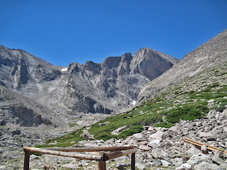
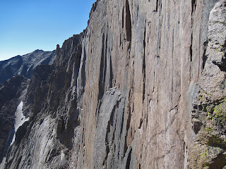
Longs Peak is perhaps Colorado’s most famous and traveled mountain, and for good reason. Longs offers a variety of routes
in many difficulty levels. Almost every one of Longs’ routes are classics. From the class 3 ultra-popular scramble of the Keyhole Route to the
mixed snow and rock mountaineering masterpiece Kiener’s Route (II 5.3 Moderate
Snow) to the alpine wall classics of the Diamond like the Casual Route (IV
5.10a) and Ariana (IV 5.12a). These are only a very small sampling of the many established routes on Longs Peak.
Situated in Rocky Mountain National Park just northwest of
Estes Park, Colorado, Longs Peak bears a high profile. It is visible from many
Front Range vantages. The classic cirque of Longs' and neighboring Mt. Meeker’s
east faces forms one of Colorado’s iconic mountain profiles. This amazing set
of vertical cliffs and steep buttresses is visible from Highway 7 far below. No
mountaineer can stare up at Longs’ elegant features and not be filled with
wonder.
How to Get There
From the intersection of Highway 36 and Highway 7 near Estes Park, follow
Highway 7 south for 9.2 miles to the Longs Peak Trailhead. There is a
campground here with about 25 sites, though it is often full. Unless you arrive
at the trailhead very early, you may find the parking lot also full. By late morning
cars line the road for a half mile or more down from the parking lot. The last
time I climbed Longs we arrived at 1:30 in the morning and the lot was nearly
empty. This trailhead is the main access for most of Longs Peaks most popular
routes including the Keyhole and all routes on the Diamond and the East Face.
Routes
A partial list of Longs’ many routes in order of difficulty:
Keyhole Route (II 3rd class)
The Loft (II 3rd class)
Northwest Couloir (II 5.0)
Notch Couloir (II 5.2 Steep Snow)
Kiener’s Route (Mountaineer’s Route) (II 5.4 Moderate Snow)
Alexander’s Chimney (III 5.5)
Keyhole Ridge (III 5.6)
Stettner’s Ledges (III 5.7)
Casual Route (IV 5.10a)
Pervertical Santuary (IV 5.10c)
Yellow Wall (IV 5.11a)
Ariana (IV 5.12a)
A closer look at some of Longs more popular routes:
Easy: Keyhole Route (class 3)
 |
| The Keyhole Ridge with the Keyhole visible right-center |
The Keyhole Route is Longs easiest and most popular route.
Many thousands of hikers and scramblers do this route every year. Although it
is a non-technical route, the class 3 terrain requires the use of hands for
balance and upward movement and the rock is loose, and quite exposed. Snow or
ice in the spring or storms in the summer can make this a serious route. The
loose rock combined with the exposure and sheer volume of people on this route
have made it one of the deadliest routes in Colorado. It seems that more deaths
occur on this route than any other in the state.
From the Longs Peak trailhead, follow the trail for 6 miles
to the Boulder Field at 12,800’. Cross the boulderfield aiming for a keyhole
shaped notch in the cliffband on the right (west) side of the north face. The
main flow of the trail and most cairns will lead you to this obvious notch.
Once you cross through the Keyhole the nature of the route changes and gets
much more difficult and exposed, making this a good place to turn around if the
weather looks like it is turning.
After the Keyhole scramble along increasing exposure to the
Trough, a long gully littered with loose rocks and the occasional class 3 move.
Ascend the Trough for about 500 feet and pass a chockstone on either side. Many
consider this the most difficult move on the route. Past the Trough continue
along the Narrows, a skinny ledge that pinches in several spots to 5 feet or
less above a three-hundred foot cliff. The climbing is exposed but easy. Reach
the bottom of the Homestretch at the end of the Narrows. Climb a ledgy crack
system and arrive abruptly on the flat summit from the south side.
Moderate: Kiener’s Route (II 5.4 Moderate Snow)
 |
| The turnoff to Chasm Lake. Upper Kiener's is visible |
Follow the Longs Peak trail for 3.5 miles to the turnoff for
Chasm Meadows. Leave the main trail and take the turn left towards Chasm Lake
and Longs Peaks astounding East Face. Hike for another mile to Chasm Lake; with
the Diamond and the Lower East Face towering above you, you know you are in a
special place.
Hike around to the back side of Chasm to Mills Glacier (more
a permanent snow field) and find the Lamb’s Slide, a steep couloir that ascends
toward the Loft. Ascend moderate snow here for nearly a thousand feet.
Conditions at the Lamb’s Slide can vary from good snow to steep rotten ice.
Depending on which you encounter you may need either pickets or ice screws or
both. Crampons and an ice axe are highly recommended.
Ascend Lamb’s Slide to where Broadway’s ledges intersect on
right. Take the highest ledge. Hike along Broad way with increasing exposure
until you reach the first of the route’s crux moves, a very narrows step around
with dramatic exposure over the lower East Face. Many people choose to rope up
here. Past this move continue to the base of the Notch Couloir.
Climb the Notch Couloir for about 40 feet and traverse right
to a dihedral or pass the base of the couloir and climb rock on its right side.
Either way you will encounter a pitch or two of low 5th class
climbing. After passing a chimney, continue along the face staying near but not
right on the edge of the Diamond’s upper edge. The exposure continues to be
amazing. Near the top do a step-around near the Diamond’s apex and continue up
easy scrambling to the summit. Descend with some rappels down the North Face
route or scramble down the Keyhole to descend.
Hard: The Casual Route (IV 5.10a)
 |
| The Diamond from Chasm View |
Along with Wyoming’s Grand Teton, the Diamond on Longs
Peak’s east face is the most sought-after destination for alpine climbing in
the Lower 48. Being the easiest way to ascend this amazing thousand-foot cliff,
the Casual Route is justifiably popular and classic.
Follow the Longs Peak trail to Chasm Meadows and take the
turn to Chasm Lake. Hike around the back of Chasm Lake to base of the obvious
cliff, the easy part of the approach is over.
In the center of Longs’s East Face, located the North Chimney, a
weakness that leads up to Broadway. Scramble, simul-climb and belay up three to
four rope-lengths of moderate but notoriously loose 5.easy to 5.6 climbing to
Broadway, an obvious ledge system. Now you are at the base of the climb.
P1- Climb a left-facing corner up easy rock in the middle of
the D1 pillar to the base of an obvious crack. (5.4)
P2- Follow a nice crack (fingers to hands) to a possible
belay stance below the infamous “flakes traverse”. Some people stop and belay
here and some prefer to link and the next pitch together (5.9).
P3- The infamous traverse. Climb up and left on good holds
with somewhat scant protection. It is often said that both leader and follower
are on the sharp end on this pitch due to the fall potential and traversing
nature. (5.7).
P4- At a spacious ledge, gain a good handcrack dihedral.
Climb a long pitch to a stance near the top of the dihedral. (5.8+).
P5- Finish the dihedral and belay from the Yellow Wall bivy
ledge. (5.8).
P6- The crux pitch. From the right side of the ledge, stem
up a corner, negotiate a chimney and reach the crux bulge. Pull the bulge and
belay at the Table Ledge. There are many pieces of fixed gear here and it is
easy to rest or pull this crux with some A0. (5.10a)
P7- Traverse up and left along the Table Ledge to Upper
Kiener’s Route (5.8). Follow Upper Kiener’s to the summit.
Descent: With ropes you can scramble down the North Face to
a set of eyebolts. Two or three single rope raps lands you at a brief
downscramble to the Boulderfield. You can also scramble down the standard
Keyhole route.
LINKS
-National Park Service webcam of Longs Peak
Follow us on Twitter!
Copyright notice: This website and all its contents are the intellectual property of www.coloradomountaineering.com and its authors. None of the content can be used or reproduced without the approval of www.coloradomountaineering.com.
Climbing and mountaineering are dangerous!! Please see the DISCLAIMER page
For information about how to contact us, visit this link
LINKS
-National Park Service webcam of Longs Peak
Visit THE ARCHIVE: A list of most of our articles sorted by department
For information about how to contact us, visit this link


No comments:
Post a Comment