Length: 22 miles
Total Elevation gain: 5,700'
Difficulty: class 3
OVERVIEW
The East Slopes (standard) route on Snowmass Mountain is one of Colorado's most spectacular 14er adventures. At 22 miles, it is a very long hike, and I recommend 2 days. Though the hike in and out will be more difficult with the extra gear, the extra time will allow you to take your time and enjoy this beautiful place. Although Snowmass Lake is very likely one of the busiest lakes in the Colorado's backcountry, it is quite beautiful and offers numerous opportunities for places to camp.
Like most climbs in the Elk Range, the East Slopes of Snowmass Mountain is steep, loose and dangerous. It has proven fatal for several mountaineers over the years. Almost the entire route once you have passed the Snowmass Lake is one slippery scree and once you have pass around 13,500' the route becomes particularly dangerous. Wear a helmet, use caution, and be careful not to climb directly underneath another party.
THE ROUTE
The long approach to the East Slopes of Snowmass Mountain is one of the longest for any standard route on a 14er in Colorado. The approach alone is over 8 miles and gains over 2,500' in elevation. The hike is long an provides some beautiful views. After 6.5 miles you must cross the creek. This can be a challenge at high spring runoff levels. Depending on the flow level/wood conditions people usually tiptoe across a log jam. If the water is low you can sometimes cross the creek directly below the jam. Not far after negotiating this obstacle, you reach the lake itself. There are many good campsites here. Beware, however, of rules against camping too close to the lake and against fire in general.
Hike along the east and south sides of the lake and find a climber's trail that starts up the loose rock on the lake's west end. The approach is over. Climb up the steepening slope along a vague climber's trail into the huge basin on Snowmass Peak's east slopes. Depending on the time of year and conditions there may be some snow to climb at the top of this basin. The usual route veers a bit south as you approach the ridge and finds a notch through the cliffs to reach the summit ridge. In dry, late-summer conditions, or if the snow covering is complete, you can hike more directly towards the summit, finding a breach in the cliffs and reaching the summit ridge near 13,900'. From here you traverse slightly onto the west side of the mountain and pick your way through some class 3 boulders to the summit.
 |
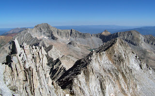
| Looking across to Capitol Peak from Snowmass's summit |
From Highway 82 28 miles south of Glenwood Springs (or 13 miles north of the roundabout in Aspen) turn west at the town of Old Snowmass (not to be confused with Snowmass Village, the ski area) onto Snowmass Creek Road. Turn left at a T-junction after a mile and a half (right will take you to Capitol). You hit the dirt road seven miles after turning off Hwy 82 and cross the creek at mile 10.5. Take a right at another intersection a half mile later and the trailhead is only about a quarter-mile beyond that.
TRIP REPORTS
 |
| The summit of Snowmass Mtn |
LINKS
East Slopes on Summitpost.org
East slopes on 14ers.com
Visit THE ARCHIVE: A list of most of our articles sorted by department


No comments:
Post a Comment